A third of India’s population currently lives in cities. It is projected that by 2030, the urban population will increase by 590 million and its economic contribution will surge to 75 per cent of GDP from the current 65 per cent. With a growing population and as centres of economic growth, Indian cities face complex infrastructural challenges and environmental degradation due to rapid urbanisation and climate change. Consequently, cities must undertake sustained actions to prepare for and develop their ability to thrive in the changing environment, writes Anshul Abbasi, Senior Associate, Climate Centre for Cities, National Institute of Urban Affairs (NIUA).

In accordance with the need for sustainable urban planning and climate-informed development actions across Indian cities, the ClimateSmart Cities Assessment Framework (CSCAF) was developed and rolled out by the Ministry of Housing and Urban Affairs (MoHUA). It is a first-of-its- kind self-assessment framework on climate-relevant parameters with an intent to provide a roadmap to Indian cities towards mainstreaming climate actions within current and future policies, programs and projects.

With a vision to be more aspirational and progressive, the current CSCAF assesses the climate performance of cities, encompassing national and international initiatives including but not limited to National Mission on Sustainable Habitat, Nationally Determined Contributions, Sustainable Development Goals and Sendai Framework for Disaster Management. In 2020, under CSCAF 2.0, 126 cities including 100 Smart Cities, capital cities and other cities were assessed on these parameters.
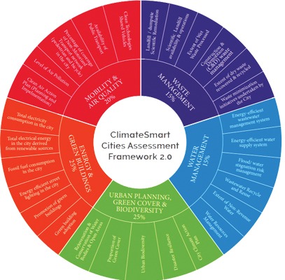
Building on the progressive approach, CSCAF recognises cities as complex systems of natural and built environments. With over 4000 urban centres and some of the fastest-growing cities, Indian cities are facing immense urban planning challenges. Further, as climate change intensifies, its impacts and the increasing number of extreme weather events pose additional risks to critical infrastructure and aggravate the vulnerability of residents. It is, therefore, important for our cities to adopt a climate-sensitive approach to urban planning. To achieve this, CSCAF 2.0 has been designed to assess cities across 28 indicators under five themes:

1. Urban Planning, Green Cover and Biodiversity
2. Energy and Green Buildings
3. Mobility and Air Quality
4. Water Management
5. Waste Management

The Urban Planning, Green Cover and Biodiversity thematic area focuses on nature-based solutions and conservation of natural systems like water bodies, green cover, open spaces and biodiversity in the city for climate mitigation and adaptation. Open and green spaces not only provide a better living environment but also play a critical role in helping people adapt to the adverse impacts of extreme climate events, combating urban heat islands, mitigating floods, maintaining biodiversity and helping reduce local temperatures. Green areas also aid in carbon sequestration, minimising the impacts of air pollution and helping recharge groundwater. Under this thematic area, cities were assessed based on the measures taken to rejuvenate and conserve open spaces, increase their green cover and conserve biodiversity.
Also Read: ClimateSmart Cities Assessment Framework Supporting Cities in Achieving SDG 11.3
Rapid urbanisation and increasing demand for built space cause open areas to either be reclaimed or encroached for development. This leads to the emergence of unplanned development as the key issue catering to environmental degradation besides the management and maintenance of open areas.

On a parallel note, conserving, rejuvenating and increasing green spaces, for instance: urban forests, help mitigate a part of the impact of climate change by reducing Urban Heat Islands (UHIs) and heat stress, reducing stormwater runoff, improving air quality, and improving health & wellbeing. In the US, urban forests reduce building energy use by 7.2 per cent, equating to an emissions reduction of 43.8 million tonnes of CO2 annually¹.
Scaling down to the needs of a citizen, World Health Organisation (WHO) prescribes 9 sqm of green space per capita in urban areas. This figure varies across Indian cities, for instance, Chennai and Pune have a meagre 0.81 sqm per capita and 1.4 sqm per capita of green cover, respectively; well below the recommended standard. On the national level, Urban and Regional Development Plans Formulation and Implementation (URDPFI) Guidelines, 2014, recommend a minimum of 12 per cent-18 per cent green cover in an urban area. Other policies and guidelines including MoHUA’s Urban Greening Guidelines, 2014, the National Mission for Green India (GIM) under National Action Plan for Climate Change (NAPCC), and the National Clean Air Programme (NCAP) also provide spatial standards for city-level green cover and identify key stakeholders for implementing greening initiatives like eco-restoration in urban and peri-urban areas and plantation schemes for pollution hotspots.
Performance of Indian Cities
As per CSCAF’s assessment of 126 cities, it is observed that cities have stark differences in green cover: ranging from less than 1 per cent to up to approximately 90 per cent. Contentedly, cities have fared well in the proportion of green cover with 65 cities meeting the prescribed URDPFI norm of 12 per cent to 18 per cent green cover within their municipal boundaries.
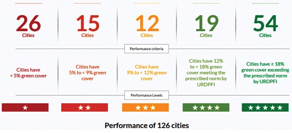
The distribution of well-performing cities (Five Stars and Four Stars) is similar across categories of towns – metropolitan cities, large cities, medium towns and small towns. Moreover, a majority of participating small towns have performed well, with seven out of the nine participant small towns featuring in the Four Stars and Five Stars category with 12 per cent to 18 per cent or more green cover.
The participant cities from Gujarat and Maharashtra have breezed through the indicator with proactive local governments ensuring timely preparation and implementation of city planning and greening measures. Cities in the north-eastern region have also shown advanced actions with eight out of 10 participant cities from the region in Four and Five Stars categories. Hilly terrain and conserved forest areas have contributed to their admirable performance. Among the top-performing cities, 10 cities have garnered special mentions, as they have exhibited appreciable actions in addition to championing prescribed spatial standards for green cover. The cities being Indore, Rajkot, Thane, Pune, Jamshedpur, Coimbatore, Salem, Varanasi, Sangli Miraj and Agra. All of these cities are part of Smart City Mission and/or AMRUT except Jamshedpur.
In achieving these targets, the challenges cities face are multipronged ranging from structural issues to a dearth of capacity both technical and infrastructural. For instance, the equitable distribution and quality of the urban green cover remain a key issue with most cities not monitoring or taking cohesive actions to improve the same. The Forest Survey of India and respective state forest departments have outlined measures like conducting Tree Census but there remains a gap in its implementation at the city level (by ULBs) and documentation of the qualitative aspects like tree density, canopy cover, native flora, etc. This may be attributed to limited mandate/ guidelines for monitoring and reporting qualitative aspects of green cover management specific to urban areas. The indicator of the Proportion of Green Cover attempts to bridge this gap by assessing both quantitative and qualitative aspects. While many cities have not initiated the mapping of open spaces, some cities have mapped up to the spatial extent and they need to build on attribute information and qualitative aspects to inform action planning.
Cities should initiate step-by-step actions in pursuance of strengthening institutional coordination, following the aforementioned guidelines, initiating action plans or developing spatial databases to inform gaps, priority areas and monitoring the impacts of actions taken. Detailed spatial maps of open areas with attributes such as area, foliage cover, type of land, ownership of land, etc. can be developed to assess the current status of green cover. Temporal map series for UHIs by using techniques like Landsat imagery, collecting air and surface area temperatures and a GIS-based map of green cover with support from the state or National Remote Sensing Centre can also be created. Qualitative data on native tree species, tree density and canopy density from ENVIS Centre on Wildlife and Protected Areas can also be obtained as native vegetation is more resilient and provides protection from natural disasters.
To strengthen institutional coordination, the environmental cell/committees, horticulture or forest department within a ULB that is in charge of increasing and maintaining green cover should ensure to include representatives from the town planning department, development authority, PWD, civil society and community group representatives wherever possible. The cell should document the progress concerning activities undertaken to increase green cover.
Also Read: CSCAF Guiding Cities in Flood Risk Management
The city master plan/ development plan/ greening guidelines should integrate sensitive biodiversity hotspots for sustained conservation. Additionally, a strategy to rejuvenate and conserve open and green areas should be developed with the same being integrated within the city development plan/ master plan.
Budgetary allocations to undertake rejuvenation and conservation of open and green areas can be set forth and tasks such as issuing utilisation certificates, implementing bylaw, notification of the area, the constitution of a committee, developing DPRs should be initiated. In case of encroachment and land acquisition for conservation initiatives, state-level conservation regulations may be followed.
Development and maintenance of a buffer zone between built and large natural areas, conducive to preserving biodiversity, can be strategised along with the promotion of biodiversity parks. Cities should encourage the active involvement of different stakeholders such as civil society, schools, government offices, NGOs and the private sector to devise and implement projects to increase urban green cover.
Being at the crossroads of urban transformation, cities have a unique opportunity to cater to sustainable and resilient development. Developing and boosting urban green cover is indispensable to achieving these targets. The CSCAF provides them with a baseline from which they can steadily work upwards to achieve successive goals. Thus achieving their target of sustainable development.