E-governance is a popular terminology today. It basically involves the use of technology to reform government work. Increasingly, geospatial technology is becoming the core to many IT programmes in the government. Geospatial Governance or g-Governance can be treated as a geospatial plug-in to e-Governance. Altogether g-Governance acts as an extended module of e-Governance with the additional functionality of geospatial technology, writes Er. Peeyush Gupta, Real Time Information Specialist, National Mission for Clean Ganga, Ministry of Jal Shakti.

Geospatial technology essentially provides a framework for integrated problem solving. To solve a problem, we need to first understand it. Geospatial technology enables us to understand problems better because it presents issues visually, in a more understandable manner. To move towards g-Governance, we need to see how e-Governance programmes can get geospatial data.

Water is a vital natural resource without which life would cease to exist. Water conservation and resources management represent some of the most critical environmental issues currently facing humankind. With the planet’s second largest population at 1.3 billion, and expectant growth to 1.7 billion by 2050, India is struggling to serve the vast majority of that population with safe and potable drinking water. Bringing clean water, toilets and hygiene to 1.3 billion people is a massive challenge. Waste discharge or surface runoff from urban, industrial, or agricultural areas is degrading the quality of surface or groundwater vital for human needs, ecosystem needs, and business operations. Effluent management is a way of reducing water quality impacts at a system or catchment level. Actions include managing effluent from the source prior to discharge, developing waste treatment and water reclamation systems, protecting affected aquatic ecosystems, supporting water sanitation projects, or providing financial resources for waste treatment. Water quality management may also include water quality rehabilitation, such as Namami Gange flagship program.
Also Read | Living with subsurface pollution by wastewater irrigation

Namami Gange is a flagship programme of the Government of India for the rejuvenation of Ganga and its tributaries. National Mission for Clean Ganga (NMCG) is the implementing authority of this program. It was constituted under the provisions of the Environment Protection Act (EPA) 1986, and is a part of the Ministry of Jal Shakti. The vision is to restore the wholesomeness of river Ganga in terms of Aviral Dhara (continuous flow) and Nirmal Dhara (unpolluted flow), along with preserving its ecological and geological entity.

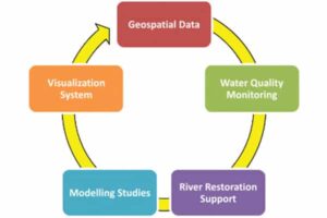
Role of Geospatial data in River Restoration
In December 2019, the first National Ganga Council meeting was convened under the Chairmanship of Honourable Prime Minister Narendra Modi. The concept of Arth Ganga is based on the symbiotic relationship between nature and society, which strives to strengthen the people river connect. Arth Ganga will channelise economic activity along the banks of Ganga river. Six key verticals for interventions viz; zero budget natural forming, monetisation & reuse of sludge & wastewater, livelihood generation opportunities, public participation, cultural heritage & tourism, and institutional building is defined under the Arth Ganga.
During the course of river Ganga’s journey from the Himalayas to the Bay of Bengal, municipal sewage from urban centres along its banks, effluents from industries, municipal solid wastes and polluting waste from several other non-point sources including agriculture get discharged into the river, resulting in its pollution. Large scale abstraction of water from river Ganga for different purposes, most substantial being for agricultural use, leads to depletion of flow in certain stretches. NMCG authority order mandates the use of geospatial information and technology in river rejuvenation, there lies an opportunity for the technology solution providers and decision-makers to tap onto the true potential of geospatial information and technologies.
Namami Gange has been recognised as India’s leading programme in using geospatial technologies towards river basin management and regulating the proposed protected and regulatory zones along the banks of the river. The flagship programme has high priority for research and evidence-based decision making and has a special place for the use of satellite information, Internet of Things (IoT), big data, digital twins, Machine Learning (ML), Blockchain technology and Artificial Intelligence (AI).

To overcome these issues, NMCG has sanctioned different GIS-based research projects touching different aspects of river rejuvenation to use geospatial data in a wide variety of areas, including legislative and policy development, allocation and management of water resources, river system spatial planning, and monitoring and basin management. Only a few of them are mentioned here.
Real time data networks for water quality management are crucial to provide an estimate of the spatial and temporal variability in water quality at a particular site. Real time data transmission from Grossly Polluting Industries through Online Continuous Effluent Monitoring System (OCEMS) is established for compliance verification. Till 31st December, 2021, 959 GPIs (out of 1080 GPIs) in river Ganga and 293 GPIs (out of 1660 GPIs) in river Yamuna basin have the connectivity of OCEMS. Water quality of river Ganga is also carried out through a network of 36 Real Time Water Quality Monitoring Stations (RTWQMS) since 2017, of which 18 stations are on main stem of river Ganga, 9 stations on tributaries and 9 stations on drains discharging into river Ganga. Real time water quality data from these stations is displayed on a web portal for visualisation. These real time stations measure water quality of river Ganga on 24×7 basis for 17 parameters, through sensors which include temperature, pH, turbidity, water level, colour, total suspended solids, conductivity, nitrates, dissolved oxygen, chemical oxygen demand, ammonia, chloride, fluoride, potassium, TOC, biochemical oxygen demand and BTX. The calibration on regular intervals is witnessed that ensures quality assured data assessment of river water quality. Recently, additional 40 real time stations have also been set up in Ganga basin. Significance of the GIS framework had brought a paradigm shift in visualisation of all crucial spatial and non-spatial information of Ganga basin to adopt accurate and transparent decisions.

Power of Geospatial Technology in G-Governance
Aquifers in the Ganga-Yamuna doab play an important role in sustaining the flows in these rivers. Ganga River Basin Management Plan recognises the importance of interplay between groundwater and surface water. Aquifer mapping project- Data generation for aquifer mapping with focus on paleo-channels in parts of Ganga-Yamuna Doab in Kaushambi- Kanpur stretch for tracking the existing paleo-channel further northwest ward for engineered ground water recharge/ augmentation, Uttar Pradesh is executing by National Geophysical Research Institute (NGRI), Hyderabad. This project will be helpful for development of a plan for managing aquifer recharge which may help in increasing the flow of river Ganga during lean season. Nature of project is tracking the inferred paleo-channel further north-west ward., 3D mapping of Principal Aquifer system, establishing linkages between aquifer system including paleo-channel with river system, estimating age profile of paleo river and climate conditions, development of a plan for Managed Aquifer Recharge.
Also Read | Effective management of wastewater is the key to managing urban rivers
The pilot project on ‘Satellite Image- derived Water Quality Research (SIWAR)–River Ganges’ was executed by World Resources Institute (WRI) India, to understand if satellite image-derived water quality measurements can effectively supplement in-situ water quality monitoring.
Way forward
G-Governance plays a key role in understanding global water cycles, mapping water courses, and monitoring and mitigating the effects of floods and droughts etc. In order to overcome these challenges, we are tapping into the power of technology. The new-gen of ‘smart’ and ‘intelligent’ technology has the ability to monitor and analyse water usage in different fields. These technologies include smart water metering, effective desalination, wastewater management through Supervisory Control and Data Acquisition (SCADA), laser seeding treatment and so on, making water systems more efficient, secure and reliable.
Namami Gange programme is adopting progressively the state of art technology like, use of space technology over cloud-based GIS platform, LiDAR technology, geo statistical analysis, big data, IoT, machine learning, blockchain, deep learning, artificial intelligence, various data collection platform such as IoT, drone etc are going to be integrated ecosystem of digital transformation and empowerment. GIS platforms are going to be used as a service for visualisation at all levels of g-Governance for rejuvenation of Ganga basin to achieve the target of SDG 6.3.