As neighbourhoods play an instrumental role in shaping one’s mental and physical development, it becomes imperative for any society to secure its future by empowering children to realise their fullest potential through access to a healthy, fair, and nurturing environment. Considering this, incorporating the requirements of children in place-making, planning, and design at the neighbourhood level can make better cities for all, writes Udit Sarkar, Geospatial Analyst, Data Analytics and Management Unit, NIUA.
The National Institute of Urban Affairs (NIUA) believes that data is a powerful tool that can bring to light hidden inequalities and give voice to the unheard. Children do not have a seat at the policymaking table and their perspectives are seldom considered. In order to overcome the challenges of limited access to data on young children or in many cases, simply a lack of data collected on them, there is a need for systematic collection, analysis and monitoring of data on the needs of children and their caregivers in terms of health, education, living conditions, environment, mobility, and play. It is imperative that such an exercise also identify the gaps in our knowledge that have inhibited evidence-based policymaking thus far. To address such data gaps in the area of urban mobility infrastructure, there is a strong case for a mobility audit, with the overarching objective being to identify how much a city is universally accessible and safe for its infants, toddlers, caregivers (ITCs). A mobile application can subsequently be designed that can help crowdsource audits of accessibility – mobility infrastructure from the perspectives of infants, toddlers, and their caregivers.

To lead these efforts, NIUA is developing frameworks and methodologies that measure the different facets of early childhood development. One of the methods for doing that involves collecting data directly from citizens and incorporating their ideas in planning and developing infrastructure in Smart Cities. Through initiatives such as Google’s Project Sidewalk that works toward reviewing the city’s sidewalks, the world is now using crowdsourcing as a tool in the development of holistic solutions to complex problems. Crowdsourcing effectively empowers the ordinary citizen to become the eyes of the municipality, and crowdsourced data could allow new parents and invested member of the community to contribute towards creating a more accessible environment for infants and toddlers.
The mobile-based application can be used by caregivers to assess accessibility during their daily commute. Since the application spatializes the information, it will help stakeholders map which streets, footpaths, crossings or bus stops are assessed and how these have been scored by users. The crowdsourced data-backed analyses thus developed can be leveraged by the city administration, planning department, academia and research organisations to influence planning guidelines for Local Area Planning (LAP), ward planning, zonal development as well as design corrective interventions to achieve a healthy, safe and accessible living environment for toddlers. Platforms such as this have been proven to be effective in the past, expediting solutions in issues ranging from the repair of potholes to the identification of accident-prone intersections. The methodology to assess accessibility in a given area would follow the parameters outlined below.

Step 1: Identifying parameters for accessibility

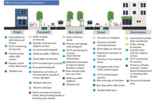
Figure 1 Macro assessment design parameters for each trip

Figure 2 Sketches of the mobile application
A child’s pattern of trips is quite different from that of an adult. It involves mostly going to school, parks or accessing nearby transit. For the purposes of this article, a complete treatment of the origin-destination trip chain was identified for toddlers, so that the toddler with the caregiver can make their journey without any barriers/ interferences. Along with the trip chain, the parameters were structured with reference to the handbooks on ITCN design Guidelines prepared by BvLF, Ministry of Social Justice and Empowerment’s Sugamya Bharat Abhiyan’s guidelines and Proximity of Care’s urban design for toddlers and disabled guideline. The assessment parameters identified for each trip shown in figure 1 are based on the recommendations provided in infant, toddler and caregiver-friendly guidelines mentioned above.
Step 2: Prioritizing parameters
What makes a trip safe and accessible to toddlers? A questionnaire listed 40 parameters encountered on each trip and asked experts to rank them in order of priority.

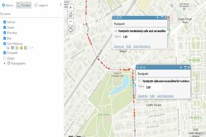
Figure 3 Trips analysed (in GIS) according to the data gathered
Step 3: Developing a web-based Accessibility Audit Toolkit
In order to develop a tool to assess accessibility, a web-based geotagged application is a pre-requisite for capturing data from the field. The tool must be carefully designed to empower the user to envision accessibility issues from a toddler’s point of view. The front-end has a feature to geo-locate the route taken for the trip and mark the issues identified on the trip in real-time. Regional languages were integrated to enhance accessibility. In order to validate crowdsourced data, the user has to upload a photograph as evidence. The data accumulated from the back-end can be analysed on a GIS platform and visualised according to the classifications mentioned in figure 2.
Figure 3 Sketches of the mobile application
Analysing the data
The data captured by the tool can be used to visualise and analyse the physical barriers a child faces at regular trip intervals. In the dashboard shown in figure 4, we have tried to visualise trip accessibility for toddlers in a Delhi neighbourhood. The barriers or issues found on the trips are spatially joined with the trip’s polyline from the route generated while walking. Trips are marked as red for unsafe/less accessible streets and green for safe/ accessible trips.
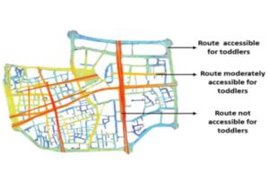
Figure 4 : Model sketch of potential output from the assessment tool
Potential Inferences/ Conclusion
The classifications of routes on the basis of spatial data and parameters’ values generated from trips can be used to identify the routes that are unsafe for toddlers and therefore need an immediate intervention of the relevant stakeholder in the city. The issues submitted by the users can also form the basis of further investigation to determine co-relations between different elements of the surrounding built environment that may have contributed to such a classification. Figure 5 is a model sketch of the neighbourhood, which clearly illustrates that the sections of the neighbourhood away from the primary roads are safe and accessible for toddlers, whereas the areas near markets or roads linking the primary roads are not safe or accessible for toddlers.
(Acknowledgement: DataSmart Urban95 project at NIUA is funded by the Bernard van Leer Foundation)