


Computer Aided Digital Mapping (CADM) is a Government of India initiative under the umbrella of Jawaharlal Nehru National Urban Renewal Mission, for providing large-scale digital maps with an aim to help in urban planning, disaster preparedness and infrastructure management. Under CADM, six metro cities across India have to be provided with digital maps on which the utility agencies shall over lay their utility network for better citizen service delivery.
Pan India, the National Remote Sensing Centre (NRSC) is doing the aerial photography in coordination with the Defence Ministry and state governments and National Informatics centre (NIC) is the agency looking after the technical support, the spatial calculations based on photogrammetry and its over all application in utility agencies.
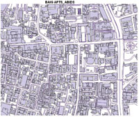
In Andhra Pradesh (AP), the first step of CADM began with the capturing of aerial photographs by the National Remote Sensing Centre (NRSC) in February 2006. The measurements through 3D aerial photographs are so close to accuracy, that the maximum variation between the actual and NRSC calculated area cannot be more than 10 cm. However, the same accuracy is almost impossible through the manual systems. It becomes quite difficult to measure the exact area that too in highly populated and concretised metros.

Labeling of the brick structures with information in the high-resolution 3D maps makes a complete ‘base map’, which can be used by the utility agencies while laying down the infrastructure. The base map is with Greater Hyderabad Municipal Corporation (GHMC) in the centrally hosted server at its HQs. To integrate and access this valuable resource, all other utility agencies need to put a leased line to the municipal HQs to connect with the main server.
GIS applications in Utility
Property tax collections
This is one of the unique applications of GIS, which results in the increase of the revenue and revenue base of the municipal corporation. Using geo-spatial information or the base map, each property details such as owner name, door number, plinth area, property tax value etc., can be viewed at a glance on the map. Traditionally, the department had to depend on the field workers for the measurements, who are often bribed by the individual property owners, resulting in the manipulation of the original figures, causing huge losses to the municipal authority in the revenue.
N S Sathya Sai Baba, Project Coordinator, NIC, said “The variation between the plinth-area calculated by NRSA and municipal corporation data for many brick structures can be identified easily with the use of this application. In a pilot that was done in the Nallakunta locality of the Hyderabad city, taking into consideration 31 properties, the GHMC figure for the total plinth area came around 94,581sft, whereas the NRSC measured the taxable area for the exact properties to about 1,84,337.58sft, resulting in a stark difference of 89,756.58sft between the two estimates.”
In revenue, the GHMC earned out of its calculations Rs.3,04,131. Though, the earnings through calculations based on the base map, the GHMC could have earned almost twice, that is, Rs. 5,87,161.55, resulting in a difference of Rs.2,83,030.55. Apparently, there has been an increase of at least 30 % – with the use of GIS technique.
Integrated Grievance Monitoring System (IGMS)
Developed with the objective of keeping citizen centricity to the core of service delivery, the NIC team in AP has designed IGMS application GHMC, with which citizens can register their complains online on roads, street lights, dumper bins, etc, check its status and get it resolved within a time frame. Each user can have a unique ID and password and can monitor their complain through the complaint number.
Over the digital map, the user can mark the exact location of the fault, while logging his/her complain. If the complain is related to a road, the road will be highlighted with red colour. Subsequently, the colour changes from red to yellow as the work is in progress and it further changes from yellow to green when the work is completed.
Metro Tech Detectors and FMS
To sort out frequent problems occurring with the Utility services, the NIC has designed an application called fault-monitoring system (FMS) where the citizens will log in to the web site and register complains. In response, the concerned utility personnel will visit the fault site and will fix the problem without taking much time. It is all done so smoothly with the help of a tool called Metro Tech Detectors.
Metro Tech Detectors has the ability to scan and detect the underground pipe and wire lines and is being distributed to utility departments. This tool helps field workers and the department to dig precisely the portion of the road or any such area beneath which the faulty pipeline lies, avoiding unnecessary wastage of time and energy and mitigate risk of damage of critical pipelines, passing nearby to the faulted one. Back to office, the personnel notify the technical team, which marks the point of correction on the digital map, which is used for future reference.
 GIS in HMWSSB and Police Department
Hyderabad Metropolitan Water Supply and Sewerage Board (HMWSSB) is also no less enthusiastic in using NRSA Base map. HMWSSB personnel detect old water pipe lines by using Metro-detectors provided by NIC under CADM Project. These lines are then detected and mapped on NRSA Data.
With the availability of the base map, the police department takes regular print out for their daily planning – the security arrangements for V-VIP and VIP movement, called as ‘bandobast’. Currently, the department is preparing clear jurisdictions boundaries with the help of NIC technical team.
 Benefits
GIS, when integrated with web application, can be an important tool in the hands of the authorities to monitor the government assets, safeguarding it from encroachment. Moreover, it saves time, resources and energy of the utility agencies in their field operations and trouble shooting, eventually enhancing the citizen service delivery.
With the integration of GIS in the workflow, the facts and figures related to the government resources have been filtered and refined. In the GHMC case, it has reduced the dependence of department on the field workers and field collectors in collection of data and revenue. It has translated in to reduced corruption and increase in revenue, by almost 30%.
Providing accurate measurements, the application adds authenticity to the government service delivery and restores public trust, besides helping the top management in decision making.
Challenges and success
The potential of GIS is enormous and is being aggressively used in many of developed nation states, in providing a clear picture of resource usage, state of education and health facilities across country. In Andhra Pradesh, though NIC team through pilots has proved the strengths of using GIS in government utilities, it is up to the departments now to adopt this innovative technique for increasing revenue, enhancing citizen service delivery, smoother laying of infrastructure and ensuring better control and monitoring over public property.
Speaking on the training of staff in utility departments, N S Sathya Sai Baba, Project Coordinator, NIC, said, “While transferring the base map to the various agencies, we trained at least five people in each of these departments. Because ultimately it’s the champions in the each of the departments who will take forward the use of technology in routine business.
For the adoption of GIS and its success at the organisational level, Sai Baba said, ” There has to be a group of motivated nodal officers or say champions in each of the utility and other government departments so that they may take the ownership and provide the consistent push required till its public acknowledgement and success.” Though many of the officials in the upper hierarchy of the state utilities have shown keen interest in GIS, a regular review of the developments, like in any government programme, by the top management will be key to the success of CADM.
Pratap Vikram Singh
pratap@egovonline.net
Be a part of Elets Collaborative Initiatives. Join Us for Upcoming Events and explore business opportunities. Like us on Facebook , connect with us on LinkedIn and follow us on Twitter, Instagram.


