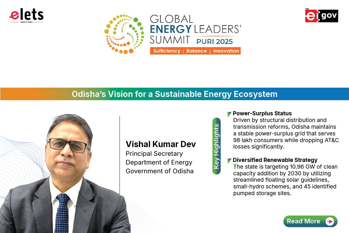


Drones fulfil this fundamental need for better, cheaper, regularly updated geospatial information about what exists now with the use of photogrammetry, image processing, and ground control points, says Ayushi Mishra, Co-founder and Chief Operating Officer (COO), Dronamaps, in this interview with Elets News Network (ENN). She further states that drones have been heavily used by the government in India for the last three to four years now and how DronaMaps is partnering with various state governments to carry out projects related to Smart City.


Ayushi Mishra, Co-founder and Chief Operating Officer (COO), Dronamaps
Can you elaborate on the UAV—based solutions that Dronamaps offers?
It is an easy to use enterprise-class solution that helps organisations extract analytics from imagery captured through drones. It is specially designed to handle the challenges of dense and unstructured geospatial data in emerging countries like India. For instance, Polavaram dam is going be one of the largest dams in Asia. Imagine you are the person in charge of rehabilitation and resettlement of 65,000 people who would lose their homes because of the dam. The problem is to decide the fate of all these people the data you have is just one location latitude and longitude with no visual understanding of the assets and gelocations. Basically, only thumbtacks marking the positions of 186 villages. It is ironic that Facebook has way more data to optimise advertisements! We at Dronamaps, started with the idea of helping this decision maker help the people.
We help large organisations save time and money by enabling the use of drones as a data gathering tool. Drone flies over the area of interest in a particular pattern (we use drone service providers to make our operations scalable and maintain quality assurance to ensure compliance with our processing framework). Once the images and ground ops are completed, the data is automatically sorted through deep learning and AI algorithms, the sorted images are then reconstructed by our 3D processing engines to create a point cloud. As byproducts of this process we receive: Orthomosaic (high resolution 2D maps), 3D maps, Contours, Digital Surface models. A hybrid of legacy geospatial, image processing, artificial intelligence, and point cloud classification approaches are applied to identify features like built-up areas, roads, and streetlights. In the precision agriculture tool kit, the identified features are biotic and abiotic stresses in plants. The map itself is raw material, the analytics ensure that it empowers decision makers to make informed decisions based on highly accurate and easy to interact with geospatial data.

We have two core specialisations: rural/ urban development and planning and precision agriculture. For instance, we are helping the city Kanpur, which is densely populated, by extracting parametric data from 3D drone based maps for property tax assessments. Traditionally, this process would cost 16 times more, and would take 4 times more time. All this does not account for the possible loss of transparency, which does happen in India. We bring a way that is not only more transparent, cost effective, reliable, faster, but also much easier for the government authorities in India to use and interpret.

Which are the projects where these UAV-based solutions have been leveraged?
Drones have been heavily used by the government in India for the last three to four years now. We have worked with the University of Berkeley in smart villages project for six state governments. We have worked on Smart City for Sagar, Property Tax assessments for Kanpur, surveying for pipelines on drone based maps in 400 sq km of rural areas in Uttar Pradesh and Madhya Pradesh border. Recently, our 3D mapping for 90 sq km of Industrial area in Gorakhpur, Uttar Pradesh, was unveiled by the state Chief Minister Yogi Adityanath. For a similar project in SEZ Indore, we have received an award for the “Most Innovative Startup” from the former Chief Minister of Madhya Pradesh, Shivraj Singh Chouhan. The maps we have created would be used for development planning and monitoring of the land use. We are exploring the possibilities of using our maps for drainage and sewage planning, flood mapping, construction planning, corridor mapping for highways. We have already worked on major infrastructure projects like the Polavaram Dam in Andhra Pradesh. In fact, our live coverage of the progress of the dam with a drone was streamed for the President of India.
What are the verticals where DronaMaps operates and what are the solutions specific to each of these verticals?

We have two core specialisations: rural/ urban development and planning and precision agriculture.
In rural/urban mapping and development we provide a web application with highly accurate geospatial information about a piece of land in 3D. Basically, authorities can view the entirety of Gurgaon in 3D, measure the heights of building, the plot areas, notice the geolocation of each tree, and assess the elevations for pipelines, all from the comfort of their laptops. The addition of a third dimension and 10 times resolution over satellite maps makes this raw data extremely potent. We build customised web based applications to aid planning and development for pipeline, creation of master plans, feature extraction and utility planning, drainage and sewage planning, monitoring of massive infrastructure projects, and their volumetric change tracking.
In precision agriculture, we work with farmers to identify the plant stresses like pest and diseases and help farmers save cost of inputs on the field while increasing yield. We have worked with Reliance Foundation and some major exporters of fruits for precision agriculture.
What is the distribution model that DronaMaps follows? Who are the SIs working with you and what is the partner structure?
We use a network of partners to help us coordinate with the government, like, SAP, Kotak Mahindra, and ESRI. In addition to these large enterprises we are also working with urban planners and surveyors to enable them to use our products to fulfill the demand from government offices they normally witness. In addition, this year, we are hoping to form deeper connects with Cisco, NEC, Honeywells of the world.
Which are the verticals that DronaMaps gets maximum traction from? Which are your marquee clients in each of these verticals?
Majority of our revenue is coming from our urban mapping and surveying vertical. Part of the reason is the openness to innovation, direct impact on governance, ability to pay for the technological prowess. However, we are also very passionate about our precision agriculture product and are nurturing it till the industry matures.
Can you elaborate on DronaMap’s collaborations with the Andhra Pradesh and the Uttar Pradesh governments?
As a nation, our technological progress is incomplete until it percolates to the villages. Our team felt strongly about bringing the technological innovations to the Indian villages. We went to the villages, conducted ethnographic studies, and took the time to understand the administrative framework that goes into decision-making. We realised that there is a need for granular data about localised regions to aid the planning and development at a grassroot level.
The Andhra Pradesh government’s openness to drones as a technology allowed us a place to grow and nurture, we worked with them on University of Berkeley’s Smart Village project, Rehabilitation and Resettlement of Polavaram Dam, and also mapped the Industrial areas of Kakinada for attracting more investments. Even our work on precision agriculture with Reliance Foundation was based near Visakhapatnam because of the support we received from the state.
Over the whole of last year, we have received massive amounts of support from the Uttar Pradesh government in testing the limits of the technology in ever more complex applications, like drainage and sewage planning, planning for pipeline networks, property tax assessments, planning for disaster mitigation etc. Gorakhpur, Lucknow, and Kanpur are some of the places we have mapped in, apart from the areas around the border for surveying for pipeline planning on the UP- MP border.
What are the advantages of drones in smart cities? What was your experience in the Sagar project?
In the year 2050, 70 percent Indians would live in cities. To support all these people you need overall infrastructure, sustainable real estate, communications, and market viability. Moreover, you would need cities where information is the principal infrastructure and the basis for providing essential services to residents. In order to design such a Smart City, one needs a digital replica of the current city with all its assets. A smart city requires oversight of the many working parts of an urban area from the public transit system to the radio towers on building tops. Converting an established urban area into a smart city begins with a 3D reconstruction that accurately maps every entity within the city. The precision of this map is extremely important, because it is the foundation of the whole system.
Drones fulfil this fundamental need for better, cheaper, regularly updated geospatial information about what exists now with the use of photogrammetry, image processing, and ground control points. The captured imagery could provide a base for collecting all the 2D and 3D features that are the last-mile problem in modelling and visualising the whole world. The major advantages of drone survey are usability, sharability, granularity, and startling savings on operational time (anywhere upto 80 percent as compared to traditional surveying methods depending on geographical challenges). With the need to advance smart city programmes quickly, drones offer flexibility, allowing surveyors to map long corridors efficiently at the start of projects and collect in-depth data to aid decision-making at an earlier stage. Instead of separating vital data in different filing cabinets, computer systems, teams or buildings, seemingly disparate pieces of information are aligned, allowing policy makers to make better decisions to the benefit of all. Integration with IoT and MIS platforms ensures that you have a geospatial anchor to all your insights. The best part about all this is that the benefits of the data do not stop at the Smart City project alone. The same data can be used for tax assessments, planning disaster mitigation, drainage and sewage planning, etc. The officials can also keep track of the volumetric changes in particular areas of interest in the city.
What are the challenges in implementation of drone-based solutions in smart cities?
For our solution of mapping and surveying, as the tenders for smart cities are massive in scale, small startups like ours which provide a niche expertise need the right support system. We have been fortunate in finding a nurturing partner network till this point but to grow over the next one year, our hope is to be involved with more government departments, SIs, and enterprises who would like to partner with us to fulfill India’s Smart City goals.
What is going to be DronaMaps roadmap in terms of products and solutions this year? What are going to be your focus areas?
Our engagements with government organisations act like paid pilots for us that make us cognizant of the features needed by the end-user based on the feedback received from our clients. It helps us understand how our product would be used on the ground and enable the process of its adaption; the second purpose it serves is helping us productise our platform and empowering our research by providing a constant set of challenges and data to work with. For this year, we are looking forward to working on Smart cities, flood management, disaster planning, surveying for highways and railway corridors.
The product is coming together bit by bit. It has been a labour intensive and harrowing process. Our team of engineers from IIT, NIT, and Johns Hopkins are taking on some of the most complex challenges in the geospatial world. It is heartening to see the positive response from government organisations.

Be a part of Elets Collaborative Initiatives. Join Us for Upcoming Events and explore business opportunities. Like us on Facebook , connect with us on LinkedIn and follow us on Twitter, Instagram.
"Exciting news! Elets technomedia is now on WhatsApp Channels Subscribe today by clicking the link and stay updated with the latest insights!" Click here!