Overview of Sri Lanka’s Domestic Transport Sector
An efficient transport service is one of the pre-conditions for economical and social development in a country. Therefore, provision of an efficient transport service:
-
leads to increase in productivity
-
reduces production cost of goods and services and thereby improving efficiency of the entire production process
-
caters to reduce economic and social discrepancies in inter-provincial and intra-provincial levels.
-
contributes to reduce poverty by means of reducing production cost, getting competitive price and paving a way to access new opportunities.
| Year | Buses % |
Railway % |
Private % |
|
| 1 | 1982 | 80 | 10 | 10 |
| 2 | 1992 | 71 | 6 | 23 |
| 3 | 2001 | 70 | 6 | 24 |
| 4 | 2005 | 68 | 6 | 26 |
| 5 | 2007 | 68 | 6 | 26 |
| 6 | 2008 | 68 | 5 | 27 |
Seventy percent of the entire population of the country lives in rural areas. Three million people live in Colombo Metropolitan area, whereas the population in the other cities range from 50,000 to 300,000. These indicators need to be considered in planning the transport facilities in Sri Lanka.
The road network in Sri Lanka consists of 11,760 kms of National Highways, 15,743 kms of Provincial Highways, 68,843 kms of rural roads and 120,000 kms of footpaths and tracks. The Railway Network consists of 1,449 kms of which only 1,200 kms is operational.

Contribution by the Different Transport Modes
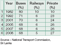
The following table indicates the Modal Share for Passenger Transport
 Sri Lanka Transport Sector –Modal Shares (Percentages) of Passenger Transport

The entire 68% of the share held by the bus transport gets distributed among public and private buses.
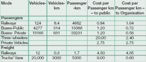
The performance of each mode of transport in 2008 is shown in the following table. The table includes an approximate cost comparison (cost per passenger /
tonne – kms) too.
NATIONAL TRANSPORT POLICY – 2009
The National Transport Policy, which has been designed by a high level committee will be accepted by the Parliament soon. It mainly focuses on 12 policy areas.
 However, the policy addresses the following key areas.
1.Optimum utilisation of available resources
2.Regulating passenger transport fares
3.Strengthening and developing state passenger transport services for operating competitively with the private companies
These are of prime importance where IT solutions can be implemented to achieve some or all of them.
APPLICATION OF ICT IN PUBLIC TRANSPORT SECTOR
ICT is an enabling technology. It can be considered as a new engine for modern transport processes, fueled by the resources and driven by the needs of the society.
ICT in transport sector is aimed at:
1.Increasing the effectiveness, efficiency and capacity of existing transportation systems. It includes information processing, communication and control
2.Ensuring safety
3.Enabling collecting and transmitting dynamic information on traffi c conditions and transiting schedules for travelers [home, en route, offi ce etc.]
4.Improving transit security and productivity through tracking and dispatching systems
ICT enables deployment resulting in higher consumer satisfaction, the ability to promote public transport, more efficient cities and lower infrastructure demands.
REGULATING PASSENGER TRANSPORT FARES
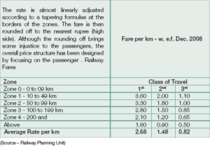
Railway Fares: The Sri Lankan Railways fares are based on a rate per km that is applicable to a zone. The zonal rate drops as the distance from the embarking station increases. This has been done by considering the affordability of people, to encourage long distance travel and to be competitive. The ticket fare is calculated based on the distance of travel in kilometres and the rate for the zones that the passenger passed.
Bus Fares: The bus fares are based on rates applicable to zones. Similar to railways, the zones spread radially from the starting point of the journey. The width of a zone is about 2 kms. There is no tapering formulae applicable to borders of the zones. So, passengers are not paying for the nearest kilometre that he travels.
The fare structure of buses brings injustice to the passenger because itdoes not harge for the exact distance (for exact number of kilometres travelled) that he ravels. This happens especially at the borders of the zones.
FARE STRUCTURE OF PUBLIC TRANSPORT
The fare structure of Public Transport Oganisations must not bring injustice to the passengers as far as possible. This does not mean that the organisations are to receive negative contributions from passenger transport (just because the government funds are available). These organisations must receive positive contributions through:
 1.Enforcing suitable pricing structure by considering the affordability of people and by being competitive.
2.Eliminating waste and inefficiencies to minimise cost (release people from bearing internal inefficiencies of organisations )
ICT can be utilised to achieve fairness and to regulate transport fares.
1.If a system is available through which, the authorities can know the exact locations of buses / trains which are engaged with journeys. assistance for decision aking can be obtained. For instance, decisions about how the rostering of buses/train ets can be improved by predicting when the bus/train will reach the destination and the best way of re-using it for other trips. The effect from breakdown of buses/trains can be reduced by rearranging the buses/train sets.
In order to address the above issues integrated Global Positioning System(GPS) based ticketing and operation mapping system is proposed.
INTEGRATED GPS (GLOBAL POSITIONING SYSTEM) BASED TICKETING AND OPERATION MAPPING SYSTEM
The system has been designed with the intension of regulating the bus fares (Train fares too, if necessary) and to achieve optimising of the available resources (Buses and Trains).
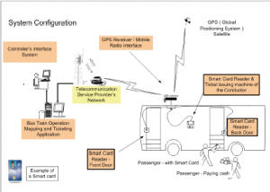
The following sketch depicts the outline
of the system.
REGULATING FARE STRUCTURE THROUGH GPS-BASED TICKETING
Features and functionality of the equipment and the system (How it works):
1. Smart Cards (SC) : The Smart Cards are issued by the TransportOrganisations SLR and SLCTB). The organisation will hold the personal details of the owner (similar to the Credit cards) when issuing the SCs. The Card bears a unique number and the price tag for which the card is valued. The SmartCards are valued at various fi xed prices (from Rs. 1000.00 upto Rs. 3000.00). They can be recharged by paying to the Transport Organisations or to their authorised agents. The remaining balance of the Card can be checked through the mobile phones (through SMS) or at the bus hrough the Conductor’s Ticketing Machine. Furthermore, it would be possible to charge the Cards through the Mobile Phone, if the Mobile Operators and Transport Organisations agree on fund transaction procedures.
2. The SC Readers in the Bus :The front and the back doors of the bus are provided with the Smart Card readers which are connected to the GPS Receiver.
The passengers having a valid SC can have his SC in the pocket and get into the bus. The reader will read the SC Number and send it to the Database along with the GPS coordinates of the locationwhere the passenger gets into the bus. If the card is not valid, the card number will be displayed and an alarm will appear at the Conductor’s terminal. The passenger can then either pay to the Conductor and get a ticket or get his Card recharged from the Conductor.
When the passenger gets down, the reader again reads the contents and informs the database along with the GPS coordinates to deduct the fare (i.e., the exact fare for the distance that the passenger travelled) from the Card.
3. If, the remaining balance is not suffi cient to cover the fare, it will be deducted for the Card when the Cardis recharged. If the passenger do not recharge, then the amount will be considered as unrecoverable expense. However, such a passenger will notbe able to purchase another card.
Conductor’s Ticketing Machine: The Conductor’s Ticketing Machine has few functions:
a.Smart Card Reader
b.Ticket Issuance
c.GPS Receiver
The conductor can read the Smart Card produced by the passenger for checking and for recharging it.
The machine has a Flash Memory (applicable to a route or few routes) having following information.
a.The bus halts (code numbers of halts) and their kilometres on the route.
b.The fare structure or the formulae for calculation
The conductor, when he starts the bus must set the route number on the machine. For calculating the fares, the conductor has to refer to the table
applicable to that route.
Note : Each Bus halt is given a Code number and it is displayed at each and every bus halt. The codes are formed by considering the kilometerage of the bus halt. The passengers can refer halts usually by their code numbers or by the names of the locations.
GPS Receiver System: Receives GPS coordinates continuously from the GPS satellites. Consists of an external antenna system to make the system more reliable. For the Conductor’s Machine, a leaky coaxial cable or a sliding antenna can be used.
The Mobile Network Connection: In addition to the GPS system, a Mobile
Radio Connection is necessary to transmit:
a.Ticketing data to the ticketing database
GPS coordinates of the buses/trains to map the entire bus/train operation for the controller.
FEATURES AND FUNCTIONALITY OF THE EQUIPMENT AND THE SYSTEM
 1. The GPS Receiver System in the Bus: The system in the bus (the same system used for Ticketing) receives the GPS coordinates of the bus from the satellite and transmits it to the of the Mapping System at the control centre through the mobile network.
2. The Database and Mapping System Application: The mapping system after receiving this information, evaluates and plots the locations of the trains/buses on a screen consisting of the road map.
The mapping system delivers the following information to the controller :
1.The map indication of the whole transport operation
2.Speed of buses/trains
3.Probable time of trains/buses reaching the destination
4.Decision support system for the controller about
a.Rostering of buses/trains
b.Controlling of trains, crossing points etc.
5.Bus/train operation information displays at bus stands/railway stations, Internet, airports, ports and allowing the citizens to query the system through mobile phones.
ENABLING OPTIMUM UTILISATION OF RESOURCES
Public bus services have limited number of buses with which a satisfactory serviceneed to be fulfilled competitively. Optimum utilisation of the available resources to cater a service which delights passengers will benefi t the country n many ways.
1.Extending a satisfactory service to the passengers
2.Reduce capital expenditure needed to purchase additional buses/trains
Integrated GPS based solutions will not only regulate the bus fares bus also achieve maximum optimisation of the available resources.
ATL PALITHA SAMARASINGHE
 ATL Palitha Samarasinghe, is Deputy Chief Signal and Telecommunication Engineer in the Sri Lanka Railways ( SLR ). He also works as the Data Processing Manager and the Chief Innovative Officer of the SLR. He has Signaling, Telecommunication and Computerisation Projects in SLR. Samarasinghe graduated from The Institution of Electronic and Radio Engineers, UK in 1986, and did Electronic , Telecommunication and Computer Systems Engineering for the degree. He is currently pursuing Masters Degree in e-Governance from the University of Moratuwa, Sri Lanka.
REFERENCE:
1.Progress Review Report 2009 – Ministry of Transport
2.National Transport Policy 2009 – Draft
3.Statistics – National Transport Commission
4.Railway Statistics
Discussions with:
– Dr. D.S. Jayaweera – Former Secretary of the Ministry of Transport
– Mr. M.A. Jefry – Director
– National Transport Commission
– Mr M.B.S. Perera – Consultant
– National Transport Commission
– Mr. J.W. Chandrasekara
– Director Planning – Ministry of
Transport
Be a part of Elets Collaborative Initiatives. Join Us for Upcoming Events and explore business opportunities. Like us on Facebook , connect with us on LinkedIn and follow us on Twitter, Instagram.


